  |
South Georgia and the South Sandwich Islands (overseas territory of the UK, also claimed by Argentina) |
 |
|
Introduction
Geography
People
Government
Economy
Communications
Transportation
Military
Transnational Issues Print This Frame Airports Hotels
|
||
 |
||
| South Georgia and the South Sandwich Islands | Introduction | Top of Page |
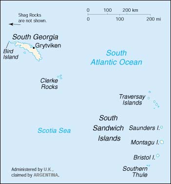
| Background: | The islands lie approximately 1,000 km east of the Falkland Islands. Grytviken, on South Georgia, was a 19th and early 20th century whaling station. The famed explorer Ernest SHACKLETON stopped there in 1914 en route to his ill-fated attempt to cross Antarctica on foot. He returned some 20 months later with a few companions in a small boat and arranged a successful rescue for the rest of his crew, stranded off the Antarctic Peninsula. He died in 1922 on a subsequent expedition and is buried in Grytviken. Today, the station houses a small military garrison. The islands have large bird and seal populations and, recognizing the importance of preserving the marine stocks in adjacent waters, the UK, in 1993, extended the exclusive fishing zone from 12 miles to 200 miles around each island. |
| South Georgia and the South Sandwich Islands | Geography | Top of Page |
| Location: | Southern South America, islands in the South Atlantic Ocean, east of the tip of South America |
| Geographic coordinates: | 54 30 S, 37 00 W |
| Map references: | Antarctic Region |
| Area: |
total:
3,903 sq km
land: 3,903 sq km water: 0 sq km note: includes Shag Rocks, Black Rock, Clerke Rocks, South Georgia Island, Bird Island, and the South Sandwich Islands, which consist of some nine islands |
| Area - comparative: | slightly larger than Rhode Island |
| Land boundaries: | 0 km |
| Coastline: | NA km |
| Maritime claims: |
exclusive fishing zone:
200 NM
territorial sea: 12 NM |
| Climate: | variable, with mostly westerly winds throughout the year interspersed with periods of calm; nearly all precipitation falls as snow |
| Terrain: | most of the islands, rising steeply from the sea, are rugged and mountainous; South Georgia is largely barren and has steep, glacier-covered mountains; the South Sandwich Islands are of volcanic origin with some active volcanoes |
| Elevation extremes: |
lowest point:
Atlantic Ocean 0 m
highest point: Mount Paget (South Georgia) 2,934 m |
| Natural resources: | fish |
| Land use: |
arable land:
0%
permanent crops: 0% permanent pastures: 0% forests and woodland: 0% other: 100% (largely covered by permanent ice and snow with some sparse vegetation consisting of grass, moss, and lichen) |
| Irrigated land: | 0 sq km (1993) |
| Natural hazards: | the South Sandwich Islands have prevailing weather conditions that generally make them difficult to approach by ship; they are also subject to active volcanism |
| Environment - current issues: | NA |
| Geography - note: | the north coast of South Georgia has several large bays, which provide good anchorage; reindeer, introduced early in this century, live on South Georgia |
| South Georgia and the South Sandwich Islands | People | Top of Page |
| Population: |
no indigenous inhabitants
note: the small military garrison on South Georgia withdrew in March 2001, to be replaced by a permanent group of scientists of the British Antarctic Survey which also has a biological station on Bird Island; the South Sandwich Islands are uninhabited (July 2001 est.) |
| South Georgia and the South Sandwich Islands | Government | Top of Page |
| Country name: |
conventional long form:
South Georgia and the South Sandwich Islands
conventional short form: none |
| Dependency status: | overseas territory of the UK, also claimed by Argentina; administered from the Falkland Islands by UK civil commissioner Donald A. LAMONT, representing Queen ELIZABETH II; Grytviken, formerly a whaling station on South Georgia, is the garrison town |
| National holiday: | Liberation Day, 14 June (1982) |
| Constitution: | adopted 3 October 1985 |
| Legal system: | the laws of the UK, where applicable, apply |
| Diplomatic representation in the US: | none (overseas territory of the UK, also claimed by Argentina) |
| Diplomatic representation from the US: | none (overseas territory of the UK, also claimed by Argentina) |
| Flag description: | the flag of the UK is used |
| South Georgia and the South Sandwich Islands | Economy | Top of Page |
| Economy - overview: | Some fishing takes place in adjacent waters. There is a potential source of income from harvesting fin fish and krill. The islands receive income from postage stamps produced in the UK. |
| Budget: |
revenues:
$291,777
expenditures: $451,000, including capital expenditures of $NA (1988 est.) |
| Electricity - production by source: |
fossil fuel:
NA%
hydro: NA% nuclear: NA% other: NA% |
| Electricity - consumption: | NA kWh |
| South Georgia and the South Sandwich Islands | Communications | Top of Page |
| Telephone system: |
general assessment:
NA
domestic: NA international: coastal radiotelephone station at Grytviken |
| Radio broadcast stations: | none |
| Television broadcast stations: | 0 (1997) |
| Internet country code: | .gs |
| South Georgia and the South Sandwich Islands | Transportation | Top of Page |
| Waterways: | none |
| Ports and harbors: | Grytviken |
| Airports: | none |
| South Georgia and the South Sandwich Islands | Military | Top of Page |
| Military - note: | defense is the responsibility of the UK |
| South Georgia and the South Sandwich Islands | Transnational Issues | Top of Page |
| Disputes - international: | claimed by Argentina |