  |
Tromelin Island (possession of France) |
 |
|
Introduction
Geography
People
Government
Economy
Communications
Transportation
Military
Transnational Issues Print This Frame Airports Hotels
|
||
 |
||
| Tromelin Island | Introduction | Top of Page |
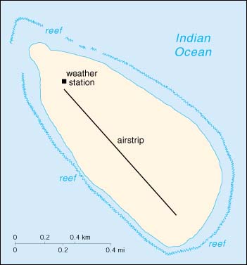
| Background: | First explored by the French in 1776, the island came under the jurisdiction of Reunion in 1814. At present, it serves as a sea turtle sanctuary and is the site of an important meteorological station. |
| Tromelin Island | Geography | Top of Page |
| Location: | Southern Africa, island in the Indian Ocean, east of Madagascar |
| Geographic coordinates: | 15 52 S, 54 25 E |
| Map references: | Africa |
| Area: |
total:
1 sq km
land: 1 sq km water: 0 sq km |
| Area - comparative: | about 1.7 times the size of The Mall in Washington, DC |
| Land boundaries: | 0 km |
| Coastline: | 3.7 km |
| Maritime claims: |
continental shelf:
200-m depth or to the depth of exploitation
exclusive economic zone: 200 NM territorial sea: 12 NM |
| Climate: | tropical |
| Terrain: | low, flat, and sandy |
| Elevation extremes: |
lowest point:
Indian Ocean 0 m
highest point: unnamed location 7 m |
| Natural resources: | fish |
| Land use: |
arable land:
0%
permanent crops: 0% permanent pastures: 0% forests and woodland: 0% other: 100% (scattered bushes) |
| Irrigated land: | 0 sq km (1993) |
| Natural hazards: | NA |
| Environment - current issues: | NA |
| Geography - note: | climatologically important location for forecasting cyclones; wildlife sanctuary |
| Tromelin Island | People | Top of Page |
| Population: | uninhabited (July 2001 est.) |
| Tromelin Island | Government | Top of Page |
| Country name: |
conventional long form:
none
conventional short form: Tromelin Island local long form: none local short form: Ile Tromelin |
| Dependency status: | possession of France; administered by a high commissioner of the Republic, resident in Reunion |
| Legal system: | the laws of France, where applicable, apply |
| Flag description: | the flag of France is used |
| Tromelin Island | Economy | Top of Page |
| Economy - overview: | no economic activity |
| Tromelin Island | Communications | Top of Page |
| Communications - note: | important meteorological station |
| Tromelin Island | Transportation | Top of Page |
| Waterways: | none |
| Ports and harbors: | none; offshore anchorage only |
| Airports: | 1 (2000 est.) |
| Airports - with unpaved runways: |
total:
1
under 914 m: 1 (2000 est.) |
| Tromelin Island | Military | Top of Page |
| Military - note: | defense is the responsibility of France |
| Tromelin Island | Transnational Issues | Top of Page |
| Disputes - international: | claimed by Madagascar and Mauritius |