  |
Namibia | 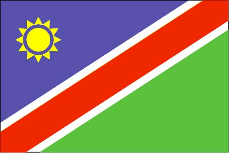 |
|
Introduction
Geography
People
Government
Economy
Communications
Transportation
Military
Transnational Issues Print This Frame Airports Hotels
|
||
 |
||
| Namibia | Introduction | Top of Page |
| Background: | South Africa occupied the German colony of Sud-West Afrika during World War I and administered it as a mandate until after World War II when it annexed the territory. In 1966 the Marxist South-West Africa People's Organization (SWAPO) guerrilla group launched a war of independence for the area that was soon named Namibia, but it was not until 1988 that South Africa agreed to end its administration in accordance with a UN peace plan for the entire region. Independence came in 1990. |
| Namibia | Geography | Top of Page |
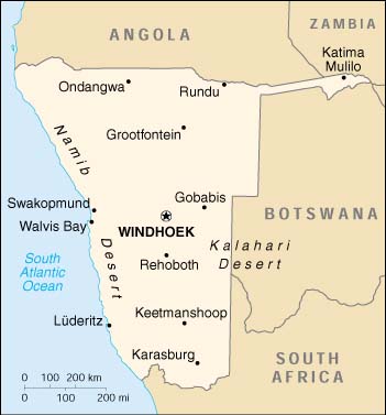
| Location: | Southern Africa, bordering the South Atlantic Ocean, between Angola and South Africa |
| Geographic coordinates: | 22 00 S, 17 00 E |
| Map references: | Africa |
| Area: |
total:
825,418 sq km
land: 825,418 sq km water: 0 sq km |
| Area - comparative: | slightly more than half the size of Alaska |
| Land boundaries: |
total:
3,824 km
border countries: Angola 1,376 km, Botswana 1,360 km, South Africa 855 km, Zambia 233 km |
| Coastline: | 1,572 km |
| Maritime claims: |
contiguous zone:
24 NM
exclusive economic zone: 200 NM territorial sea: 12 NM |
| Climate: | desert; hot, dry; rainfall sparse and erratic |
| Terrain: | mostly high plateau; Namib Desert along coast; Kalahari Desert in east |
| Elevation extremes: |
lowest point:
Atlantic Ocean 0 m
highest point: Konigstein 2,606 m |
| Natural resources: |
diamonds, copper, uranium, gold, lead, tin, lithium, cadmium, zinc, salt, vanadium, natural gas, hydropower, fish
note: suspected deposits of oil, coal, and iron ore |
| Land use: |
arable land:
1%
permanent crops: 0% permanent pastures: 46% forests and woodland: 22% other: 31% (1993 est.) |
| Irrigated land: | 60 sq km (1993 est.) |
| Natural hazards: | prolonged periods of drought |
| Environment - current issues: | very limited natural fresh water resources; desertification |
| Environment - international agreements: |
party to:
Antarctic-Marine Living Resources, Biodiversity, Climate Change, Desertification, Endangered Species, Hazardous Wastes, Law of the Sea, Ozone Layer Protection, Wetlands
signed, but not ratified: none of the selected agreements |
| Geography - note: | first country in the world to incorporate the protection of the environment into its constitution; some 14% of the land is protected, including virtually the entire Namib Desert coastal strip |
| Namibia | People | Top of Page |
| Population: |
1,797,677
note: estimates for this country explicitly take into account the effects of excess mortality due to AIDS; this can result in lower life expectancy, higher infant mortality and death rates, lower population and growth rates, and changes in the distribution of population by age and sex than would otherwise be expected (July 2001 est.) |
| Age structure: |
0-14 years:
42.74% (male 389,028; female 379,229)
15-64 years: 53.54% (male 480,075; female 482,375) 65 years and over: 3.72% (male 29,109; female 37,861) (2001 est.) |
| Population growth rate: | 1.38% (2001 est.) |
| Birth rate: | 34.71 births/1,000 population (2001 est.) |
| Death rate: | 20.9 deaths/1,000 population (2001 est.) |
| Net migration rate: | 0 migrant(s)/1,000 population (2001 est.) |
| Sex ratio: |
at birth:
1.03 male(s)/female
under 15 years: 1.03 male(s)/female 15-64 years: 1 male(s)/female 65 years and over: 0.77 male(s)/female total population: 1 male(s)/female (2001 est.) |
| Infant mortality rate: | 71.66 deaths/1,000 live births (2001 est.) |
| Life expectancy at birth: |
total population:
40.62 years
male: 42.48 years female: 38.71 years (2001 est.) |
| Total fertility rate: | 4.83 children born/woman (2001 est.) |
| HIV/AIDS - adult prevalence rate: | 19.54% (1999 est.) |
| HIV/AIDS - people living with HIV/AIDS: | 160,000 (1999 est.) |
| HIV/AIDS - deaths: | 18,000 (1999 est.) |
| Nationality: |
noun:
Namibian(s)
adjective: Namibian |
| Ethnic groups: |
black 87.5%, white 6%, mixed 6.5%
note: about 50% of the population belong to the Ovambo tribe and 9% to the Kavangos tribe; other ethnic groups are: Herero 7%, Damara 7%, Nama 5%, Caprivian 4%, Bushmen 3%, Baster 2%, Tswana 0.5% |
| Religions: | Christian 80% to 90% (Lutheran 50% at least), indigenous beliefs 10% to 20% |
| Languages: | English 7% (official), Afrikaans common language of most of the population and about 60% of the white population, German 32%, indigenous languages: Oshivambo, Herero, Nama |
| Literacy: |
definition:
age 15 and over can read and write
total population: 38% male: 45% female: 31% (1960 est.) |
| Namibia | Government | Top of Page |
| Country name: |
conventional long form:
Republic of Namibia
conventional short form: Namibia former: German Southwest Africa, South-West Africa |
| Government type: | republic |
| Capital: | Windhoek |
| Administrative divisions: | 13 regions; Caprivi, Erongo, Hardap, Karas, Khomas, Kunene, Ohangwena, Okavango, Omaheke, Omusati, Oshana, Oshikoto, Otjozondjupa |
| Independence: | 21 March 1990 (from South African mandate) |
| National holiday: | Independence Day, 21 March (1990) |
| Constitution: | ratified 9 February 1990; effective 12 March 1990 |
| Legal system: | based on Roman-Dutch law and 1990 constitution |
| Suffrage: | 18 years of age; universal |
| Executive branch: |
chief of state:
President Sam Shafishuna NUJOMA (since 21 March 1990); note - the president is both the chief of state and head of government
head of government: President Sam Shafishuna NUJOMA (since 21 March 1990); note - the president is both the chief of state and head of government cabinet: Cabinet appointed by the president from among the members of the National Assembly elections: president elected by popular vote for a five-year term; election last held 30 November-1 December 1999 (next to be held NA 2004) election results: Sam Shafishuna NUJOMA elected president; percent of vote - Sam Shafishuna NUJOMA 77% |
| Legislative branch: |
bicameral legislature consists of the National Council (26 seats; two members are chosen from each regional council to serve six-year terms) and the National Assembly (72 seats; members are elected by popular vote to serve five-year terms)
elections: National Council - elections for regional councils, to determine members of the National Council, held 30 November-1 December 1998 (next to be held by December 2004); National Assembly - last held 30 November-1 December 1999 (next to be held by December 2004) election results: National Council - percent of vote by party - NA%; seats by party - SWAPO 21, DTA 4, UDF 1; National Assembly - percent of vote by party - SWAPO 76%, COD 10%, DTA 9%, UDF 3%, MAG 1%, other 1%; seats by party - SWAPO 55, COD 7, DTA 7, UDF 2, MAG 1, note: the National Council is primarily an advisory body |
| Judicial branch: | Supreme Court (judges appointed by the president on the recommendation of the Judicial Service Commission) |
| Political parties and leaders: | Congress of Democrats or COD [Ben ULENGA]; Democratic Turnhalle Alliance of Namibia or DTA [Katuutire KAURA, president]; Monitor Action Group or MAG [Kosie PRETORIUS]; South West Africa People's Organization or SWAPO [Sam NUJOMA]; United Democratic Front or UDF [Justus GAROEB] |
| Political pressure groups and leaders: | NA |
| International organization participation: | AfDB, C, CCC, ECA, FAO, G-77, IAEA, IBRD, ICAO, ICRM, IFAD, IFC, IFRCS, ILO, IMF, IMO, Intelsat, Interpol, IOC, IOM (observer), ISO (correspondent), ITU, NAM, OAU, OPCW, SACU, SADC, UN, UNCTAD, UNESCO, UNHCR, UNIDO, UNMEE, UNTAET, UPU, WCL, WHO, WIPO, WMO, WToO, WTrO |
| Diplomatic representation in the US: |
chief of mission:
Ambassador Leonard Nangolo IIPUMBU
chancery: 1605 New Hampshire Avenue NW, Washington, DC 20009 telephone: [1] (202) 986-0540 FAX: [1] (202) 986-0443 |
| Diplomatic representation from the US: |
chief of mission:
Ambassador Jeffrey A. BADER
embassy: Ausplan Building, 14 Lossen Street, Windhoek mailing address: Private Bag 12029 Ausspannplatz, Windhoek telephone: [264] (61) 221601 FAX: [264] (61) 229792 |
| Flag description: | a large blue triangle with a yellow sunburst fills the upper left section and an equal green triangle (solid) fills the lower right section; the triangles are separated by a red stripe that is contrasted by two narrow white-edge borders |
| Namibia | Economy | Top of Page |
| Economy - overview: | The economy is heavily dependent on the extraction and processing of minerals for export. Mining accounts for 20% of GDP. Namibia is the fourth-largest exporter of nonfuel minerals in Africa and the world's fifth-largest producer of uranium. Rich alluvial diamond deposits make Namibia a primary source for gem-quality diamonds. Namibia also produces large quantities of lead, zinc, tin, silver, and tungsten. Half of the population depends on agriculture (largely subsistence agriculture) for its livelihood. Namibia must import some of its food. Although per capita GDP is four times the per capita GDP of Africa's poorer countries, the majority of Namibia's people live in pronounced poverty because of large-scale unemployment, the great inequality of income distribution, and the large amount of wealth going to foreigners. The Namibian economy has close links to South Africa. GDP growth in 2000 was led by gains in the diamond and fish sectors. Agreement has been reached on the privatization of several more enterprises in coming years, which should stimulate long-run foreign investment. Growth in 2001 could be 5.5% provided the world economy remains stable. |
| GDP: | purchasing power parity - $7.6 billion (2000 est.) |
| GDP - real growth rate: | 4% (2000 est.) |
| GDP - per capita: | purchasing power parity - $4,300 (2000 est.) |
| GDP - composition by sector: |
agriculture:
12%
industry: 25% services: 63% (1999 est.) |
| Population below poverty line: | NA% |
| Household income or consumption by percentage share: |
lowest 10%:
NA%
highest 10%: NA% |
| Inflation rate (consumer prices): | 9.1% (2000) |
| Labor force: | 500,000 |
| Labor force - by occupation: | agriculture 47%, industry 20%, services 33% (1999 est.) |
| Unemployment rate: | 30% to 40%, including underemployment (1997 est.) |
| Budget: |
revenues:
$883 million
expenditures: $950 million, including capital expenditures of $NA (1998) |
| Industries: | meatpacking, fish processing, dairy products; mining (diamond, lead, zinc, tin, silver, tungsten, uranium, copper) |
| Industrial production growth rate: | NA |
| Electricity - production: | 1.198 billion kWh (1999) |
| Electricity - production by source: |
fossil fuel:
2%
hydro: 98% nuclear: 0% other: 0% (1999) |
| Electricity - consumption: | 1.948 billion kWh (1999) |
| Electricity - exports: | 56 million kWh (1999) |
| Electricity - imports: |
890 million kWh
note: supplied by South Africa (1999) |
| Agriculture - products: | millet, sorghum, peanuts; livestock; fish |
| Exports: | $1.4 billion (f.o.b., 2000 est.) |
| Exports - commodities: | diamonds, copper, gold, zinc, lead, uranium; cattle, processed fish, karakul skins |
| Exports - partners: | UK 43%, South Africa 26%, Spain 14%, France 8%, Japan (1998 est.) |
| Imports: | $1.6 billion (f.o.b., 2000 est.) |
| Imports - commodities: | foodstuffs; petroleum products and fuel, machinery and equipment, chemicals |
| Imports - partners: | South Africa 81%, US 4%, Germany 2% (1997 est.) |
| Debt - external: | $217 million (2000 est.) |
| Economic aid - recipient: | $127 million (1998) |
| Currency: | Namibian dollar (NAD); South African rand (ZAR) |
| Currency code: | NAD; ZAR |
| Exchange rates: | Namibian dollars per US dollar - 7.78307 (January 2001), 6.93983 (2000), 6.10948 (1999), 5.52828 (1998), 4.60796 (1997), 4.29935 (1996) |
| Fiscal year: | 1 April - 31 March |
| Namibia | Communications | Top of Page |
| Telephones - main lines in use: | 100,848 (1997) |
| Telephones - mobile cellular: | NA |
| Telephone system: |
general assessment:
good system; about 6 telephones for each 100 persons
domestic: good urban services; fair rural service; microwave radio relay links major towns; connections to other populated places are by open wire; 100% digital international: fiber-optic cable to South Africa, microwave radio relay link to Botswana, direct links to other neighboring countries; connected to Africa ONE and South African Far East (SAFE) submarine cables through South Africa; satellite earth stations - 4 Intelsat |
| Radio broadcast stations: | AM 2, FM 34, shortwave 5 (1998) |
| Radios: | 232,000 (1997) |
| Television broadcast stations: | 8 (plus about 20 low-power repeaters) (1997) |
| Televisions: | 60,000 (1997) |
| Internet country code: | .na |
| Internet Service Providers (ISPs): | 2 (2000) |
| Internet users: | 9,000 (1999) |
| Namibia | Transportation | Top of Page |
| Railways: |
total:
2,382 km
narrow gauge: 2,382 km 1.067-m gauge; single-track (2001) |
| Highways: |
total:
63,258 km
paved: 5,250 km unpaved: 58,008 km (1997 est.) |
| Waterways: | none |
| Ports and harbors: | Luderitz, Walvis Bay |
| Merchant marine: | none (2000 est.) |
| Airports: | 131 (2000 est.) |
| Airports - with paved runways: |
total:
21
over 3,047 m: 2 2,438 to 3,047 m: 2 1,524 to 2,437 m: 13 914 to 1,523 m: 4 (2000 est.) |
| Airports - with unpaved runways: |
total:
110
2,438 to 3,047 m: 2 1,524 to 2,437 m: 21 914 to 1,523 m: 69 under 914 m: 18 (2000 est.) |
| Namibia | Military | Top of Page |
| Military branches: | National Defense Force (Army), Police |
| Military manpower - availability: | males age 15-49: 427,067 (2001 est.) |
| Military manpower - fit for military service: | males age 15-49: 255,016 (2001 est.) |
| Military expenditures - dollar figure: | $104.4 million (2001) |
| Military expenditures - percent of GDP: | 2.6% (FY97/98) |
| Namibia | Transnational Issues | Top of Page |
| Disputes - international: | none |